Bücher versandkostenfrei*100 Tage RückgaberechtAbholung in der Wunschfiliale


Ihr Gutschein zum Schulstart: 15% Rabatt11 auf Kalender & Schreibwaren mit dem Code DATUM15
Jetzt einlösen
mehr erfahren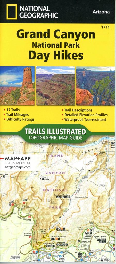
Zustellung: Mi, 10.09. - Fr, 12.09.
Sofort lieferbar
VersandkostenfreiBestellen & in Filiale abholen:
- Waterproof - Tear-Resistant - Topographic Map
Sculpted by the Colorado River, stretching 278 miles long and one mile deep, the Grand Canyon is without a doubt one of the most incredible examples of erosion on earth. First protected in 1893 as a forest reserve and later a national monument, the Grand Canyon eventually became a national park in 1919. Sixty years later, in 1979, the Grand Canyon was recognized as a World Heritage Site for its geologic significance, natural beauty, biological environments, and diverse topography. One of the seven wonders of the natural world, the Grand Canyon is truly a bucket-list stop. This spectacular wilderness with endless cliffs and canyons, varying biodiversity, and unique geologic features has something for everyone.
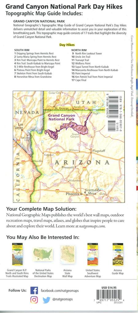
The Grand Canyon National Park Day Hikes Topographic Map Guide contains detailed maps for 18 of Grand Canyon's finest day hikes. It includes well-known hikes and some off-the-beaten-path trails. They range from easy strolls to strenuous climbs, selected to give you a sampling of all the park has to offer. Together, they cover more than 100 miles of adventures. One-third of the selected hikes are less than 6 miles long, two-thirds are less than 8 miles, and two hikes are longer than 12 miles long.
Each of the 18 maps include directions to the trailhead, the total distance to complete the hike, and an estimate of the degree of difficulty. Also provided are elevations of key points on the trail, an elevation profile for the hike, and a calculation of the hike's total elevation gain. Concise trail descriptions will help you find the hikes that best suit your interests, conditioning, and available time.
Every Trails Illustrated map is printed on "Backcountry Tough" waterproof, tear-resistant paper. A full UTM grid is printed on the map to aid with GPS navigation. Every map purchase helps support the National Geographic Society, an impact driven, nonprofit organization with global reach that uses the power of science, exploration, education, and storytelling to illuminate and protect the wonder of our world.
Sculpted by the Colorado River, stretching 278 miles long and one mile deep, the Grand Canyon is without a doubt one of the most incredible examples of erosion on earth. First protected in 1893 as a forest reserve and later a national monument, the Grand Canyon eventually became a national park in 1919. Sixty years later, in 1979, the Grand Canyon was recognized as a World Heritage Site for its geologic significance, natural beauty, biological environments, and diverse topography. One of the seven wonders of the natural world, the Grand Canyon is truly a bucket-list stop. This spectacular wilderness with endless cliffs and canyons, varying biodiversity, and unique geologic features has something for everyone.
The Grand Canyon National Park Day Hikes Topographic Map Guide contains detailed maps for 18 of Grand Canyon's finest day hikes. It includes well-known hikes and some off-the-beaten-path trails. They range from easy strolls to strenuous climbs, selected to give you a sampling of all the park has to offer. Together, they cover more than 100 miles of adventures. One-third of the selected hikes are less than 6 miles long, two-thirds are less than 8 miles, and two hikes are longer than 12 miles long.
Each of the 18 maps include directions to the trailhead, the total distance to complete the hike, and an estimate of the degree of difficulty. Also provided are elevations of key points on the trail, an elevation profile for the hike, and a calculation of the hike's total elevation gain. Concise trail descriptions will help you find the hikes that best suit your interests, conditioning, and available time.
Every Trails Illustrated map is printed on "Backcountry Tough" waterproof, tear-resistant paper. A full UTM grid is printed on the map to aid with GPS navigation. Every map purchase helps support the National Geographic Society, an impact driven, nonprofit organization with global reach that uses the power of science, exploration, education, and storytelling to illuminate and protect the wonder of our world.
- Map Scale = 1:31,680
- Folded Size = 4.25" x 9.38"
Mehr aus dieser Reihe


Produktdetails
Erscheinungsdatum
20. Dezember 2023
Sprache
englisch
Auflage
2023rd ed
Seitenanzahl
48
Reihe
NGS National Parks US
Illustrationen
48 Maps; 48 Maps
Verlag/Hersteller
Produktart
Blätter und Karten
Abbildungen
48 Maps; 48 Maps
Maßstab
1:31680
Gewicht
94 g
Größe (L/B/H)
234/107/7 mm
ISBN
9781566959070
Entdecken Sie mehr
Bewertungen
0 Bewertungen
Es wurden noch keine Bewertungen abgegeben. Schreiben Sie die erste Bewertung zu "Grand Canyon National Park" und helfen Sie damit anderen bei der Kaufentscheidung.