Bücher versandkostenfrei*100 Tage RückgaberechtAbholung in der Wunschfiliale


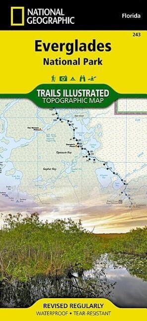
Everglades National Park Map
(0 Bewertungen)15
Blätter und Karten
Blätter und Karten

15,99 €inkl. Mwst.
Zustellung: Di, 26.08. - Sa, 30.08.
Versand in 2 Wochen
VersandkostenfreiBestellen & in Filiale abholen:
This Trails Illustrated topographic map for Everglades National Park and surrounding area is the perfect map for hiking, boating, paddling, biking, fishing, exploring, camping, and sightseeing in this unique national treasure. This two-sided map includes the Key Largo, Everglades City, Chokoloskee, Everglades National Park, portions of Big Cypress National Preserve, Fakahatchee Strand State Preserve, Cape Romano Ten Thousand Islands Aquatic Preserve, Shark Valley Tram Road, Old Ingraham highway and campsite, North Nest Key, West Lake Canoe Trail, Snake Bight Trail, backcountry campsites, beach sites, ground sites, and chickees, and detailed insets of Flamingo, Whitewater Bay, Pineland Trails of the Long Pine Key area, and Nine Mile Pond. The map also shows the entire Wilderness Waterway, from the Gulf Coast Visitor Center near Everglades City to its terminus beyond the Flamingo Visitor Center. Includes UTM grids for use with your GPS unit.
Produktdetails
Erscheinungsdatum
01. Januar 2022
Sprache
englisch
Untertitel
2022nd edition.
Sprache: Englisch.
Auflage
2022nd edition
Seitenanzahl
2
Autor/Autorin
National Geographic Maps - Trails Illustrated
Verlag/Hersteller
Produktart
Blätter und Karten
Gewicht
95 g
Größe (L/B/H)
236/116/9 mm
ISBN
9781566954099
Bewertungen
0 Bewertungen
Es wurden noch keine Bewertungen abgegeben. Schreiben Sie die erste Bewertung zu "Everglades National Park Map" und helfen Sie damit anderen bei der Kaufentscheidung.